I am an avid iPhone user. But the telephone capability has been the least used application on my iPhone! There are thousands of photography applications for the iPhone, and as a landscape photographer, I have searched and found apps that have become invaluable to my photography. While some of the apps mentioned may be available for Android phones, my total experience has been with the iPhone.
In this series of posts, I will not discuss image “processing” apps – and there are hundreds and hundreds of them! Nor will I discuss apps that work in conjunction with the iPhone camera. Rather, the reason my iPhone never leaves my photo vest when I’m out shooting, is because I use apps that help me make better images with my DSLR.
In today’s post, I’ll discuss just one app that helps me anticipate and plan for the light. Landscape photographers love being in fantastic locations and we work hard to create the perfect composition. But if the light isn’t “right,” you get nothing more than a mediocre photograph. Learning to “light the landscape” requires knowledge about the sun – it’s location, it’s elevation, it’s intensity, the degree of cloud cover, etc. After sunset, the moon becomes the main illuminator, and you must know much of the same information as for the sun. While there are numerous web resources to help provide this information, having all of this in your pocket is invaluable.
Today’s App – LightTrac by Rivolu Pte.
My go-to app to plan for the light is LightTrac. The app costs $4.99 at the iTunes Store and is a bargain!
To optimize your shooting experience, you want the camera to be in the ideal position relative to your subject and to the sun, or the moon. LightTrac works on the iPhone, iPad and iPod, and Android devices, and just a few examples of the information it provides are:
• Sunrise, sunset, twilight times for any day, and at any location
• Moonrise, moonset, and moon phases for any day, plus the day and time for the full moon, new moon, and other moon phases
• The angle and elevation of the sun and moon for any location, on any date
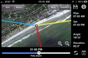
This information is superimposed on a map, which shows how your subject will be illuminated. LightTrac doesn’t just provide data. Its user interface is extremely visual and easy to use. Here’s the main screen, with the Folly Beach, S.C. pier selected as the photographic subject (in the far right side of the screen), and the photographer and camera positioned on the beach (the little white circle), shooting towards the pier. Look at the picture of the pier at the beginning of this post. See how the position of the sun matches what LightTrac showed? I positioned myself on the beach knowing exactly where the sun would be in relationship to the pier, at sunrise.

As you can see, in addition to all the information presented, the app visually shows the direction of the sunlight from sunrise to sunset on any given day and time, and the same for the moon from moonrise to moonset. You can select to see that information superimposed over a satellite map or a street map of the location where you are shooting. In this example, the white circle is your location and the yellow line is the direction of the sunlight at sunrise. The blue line is direction of the sunlight at sunset. By moving the slider near the bottom of the screen, the red line shows the sun location and direction at any time you select (in this screen shot, at 1pm). Notice you can change the date by clicking on the calendar. The Elevation data on the bottom left side of the screen provides a sense of the shadow length at any time during the day, which obviously changes, depending on the time of year.
Locations can be searched for in advance, and can be saved as favorite locations. Before any photo trip, I save the locations of the main locations I plan to shoot, and analyze how the sunlight will illuminate my key subjects. I will know the best time of day for shooting at each location, and can optimize my shooting schedule. A little bit of planning can save valuable time, and can hopefully, help you to get that perfect shot!
Other apps that provide similar information, in some cases more, and in some cases presented differently, are The Photographer’s Ephemeris and Helios . As with all apps, carefully read the the reviews in the iTunes store. You will learn a lot!
While LightTrac provides information on both the sun and the moon, Rivolu Pte also provides a complementary program ($2.99) with extensive additional information about the moon, which I highly recommend VisiMoon by Rivolu Pte.
Our next blog post in this “An App a Day” series will discuss apps for the weather, especially minute-to-minute radar maps of the location where you’re shooting. Look for that post early next week. We’ll then continue the series with apps for optimizing the depth of field of your photographs, whether maximizing or minimizing what’s in focus.
If you have favorite apps for planning for the light, let’s hear about them in the Comment box below!


Great post. With all the talk about Hipstamatic and other shooting/processing, it’s refreshing to learn about apps that can be used by photographers and their old school (well relatively) cameras. I’ll stay tuned for Part II!
You just opened up an entire new avenue of apps to explore that would never have occurred to me. Heading to the app store now…looking forward to the next installment!
Allan,
Great blog. I’ve used Photographer’s Ephemeris and now have switched to Sun Seeker. I think it’s $5.99 at iTunes. Really good app. A great thread sharing all the apps for photographers. Take care.
Very enLIGHTENING. I am going shopping.